Log in
All resources
Create a design
4,035 Free Images of World Map
a system of modern geography (1810)
bibliothèque nationale de france
continent
earth
globe
global
sphere
maps
geography
planet
cornelius aurelius world map
parrots in engravings
german renaissance,northern renaissance
portrait paintings of men on stamps
atlas van der hagen (volume 4)
people with animals in art
astronomy
planet
astronomy
planet
adrianus johannes bik
diponegoro
planet
earth
meeting the sun - a journey all round the world (1874)
maps of the temple of heaven
commemorative stamps of the united states
1931 stamps of the united states
maps by jodocus hondius
1590s maps of the world
antoine-françois tardieu
jean-baptiste poirson
atlas ou representation du monde universel t. 2 (1633)
maps by hendrik hondius the younger
atlas ou representation du monde universel t. 2 (1633)
old maps of the republic of genoa
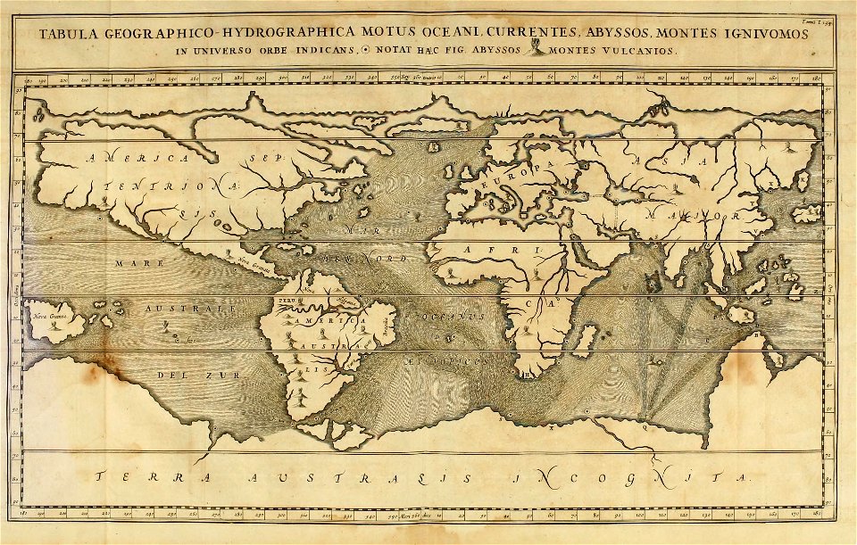
mappe-monde geo-hydrographique (sanson and jaillot, 1674)
bibliothèque nationale de france
lawrence h. slaughter collection of english maps, charts, globes, books and atlases
covens en mortier
background
maps
15th-century maps of rome
alessandro strozzi
science
geology
maps by joachim bormeester
1685 maps
maps in the library of congress
old maps of antigua and barbuda
coats of arms of the kingdom of navarre
coats of arms of the crown of aragon
a system of modern geography (1810)
1810s maps of the pacific ocean
a system of modern geography (1810)
1810s maps of italy
a system of modern geography (1810)
1810s maps of france
a system of modern geography (1810)
old maps of the holy land
a system of modern geography (1810)
1810s maps of scotland
a system of modern geography (1810)
1810s maps of china
19th-century maps of the malay archipelago
a system of modern geography (1810)
a system of modern geography (1810)
1810s maps of iran
a system of modern geography (1810)
1810s maps of canada
19th-century maps of england and wales
a system of modern geography (1810)
a system of modern geography (1810)
1810s maps of turkey
a system of modern geography (1810)
1810s maps of switzerland
a system of modern geography (1810)
1810s maps of france
a system of modern geography (1810)
1810s maps of ireland
a system of modern geography (1810)
1810s maps of the balkans
a system of modern geography (1810)
1810s maps of the netherlands
a system of modern geography (1810)
1810s maps of asia
a system of modern geography (1810)
1810s maps of denmark
a system of modern geography (1810)
old maps of the holy land
a system of modern geography (1810)
1810s maps of south america
a system of modern geography (1810)
1810 maps of the united states
mercator 1587 world map
ateliers bmb mercator
planet
city
1810s maps of the iberian peninsula
a system of modern geography (1810)
a system of modern geography (1810)
1810s maps of the russian empire
a system of modern geography (1810)
1810s maps of the austrian empire
a system of modern geography (1810)
1810s maps of germany
a system of modern geography (1810)
1810s maps of europe
a system of modern geography (1810)
1810s maps of arabia
continent
maps
19th-century maps of europe
maps by john cary
corona and coronet (1898)
travel maps of the world
school
planet
earth
globe
planet
earth
1840s maps showing history
maps by thomas starling
19th-century maps of europe
maps by john cary
planet
earth
old maps of the sinai peninsula
1870s maps of palestine
riga in the 17th century
old maps of riga
maps by emanuel bowen
1740 maps
1750s maps of the caribbean
maps by thomas kitchin
liber qvartvs contrafactur vnd beschreibung von den vornembsten stten der welt (zzk 0.32)
patrimonium 2 (project)
liber qvartvs contrafactur vnd beschreibung von den vornembsten stten der welt (zzk 0.32)
patrimonium 2 (project)
18th-century maps of north africa
maps by tomas lopez
maps by pieter van der keere
old maps of gelderland
bibliothèque nationale de france
sanson map of lorraine
redeeming the republic (1890)
1890s maps showing history
earth
maps
bibliothèque nationale de france
maps by tomas lopez
maps of ghent by braun & hogenberg
siege of ghent (1583–1584)
business & finance glyph v4 pack
maps
juan de la cruz cano y olmedilla
maps by tomas lopez
juan de la cruz cano y olmedilla
maps by tomas lopez
maps in the library of congress
1750s maps of the americas
geological maps of england
william smith (geologist)
maps of the ottoman empire by mercator-hondius
map
planet
maps
mappe-monde geo-hydrographique (sanson and jaillot, 1674)
bibliothèque nationale de france
maps of south america by mercator-hondius
bibliothèque nationale de france
old maps of the eastern hemisphere
1680s maps of the world
maps of alsace by guillaume sanson
1690s maps of alsace
1690s maps of baden-württemberg
1690s maps of alsace
description de l'universe
1680s maps of the world
planet
city
1727 maps of africa
1720s maps of egypt
background
maps
liber qvartvs contrafactur vnd beschreibung von den vornembsten stten der welt (zzk 0.32)
patrimonium 2 (project)
17th-century maps of the indian ocean
maps by willem and johannes blaeu
bibliothèque nationale de france
sanson map of lorraine
maps of the course of the rhine by guillaume sanson
bibliothèque nationale de france
illustration
business
1900s maps of arabia
william patten
background
maps
background
maps
background
maps
atlas ou representation du monde universel t. 1 (1633)
1630s maps of the netherlands
map of the upper rhenian circle by sanson
1690s maps of hesse
cartography
maps
3001 - 3100 of 4,035
Next page
/ 41


![Titelblad] AFRICA](https://cdn.creazilla.com/illustrations/10000408184/titelblad-africa-sm.webp)


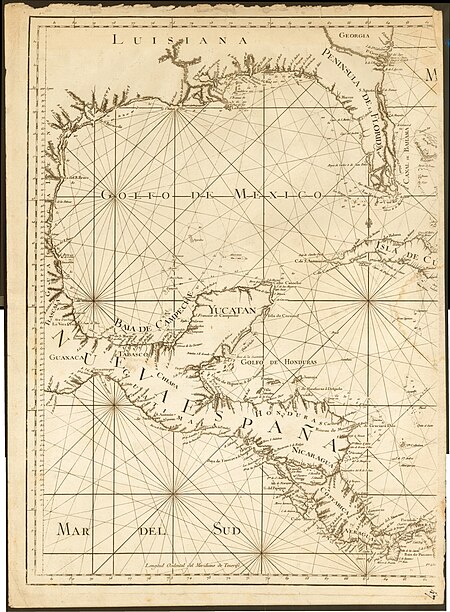
![Map of St Domingue by JB Poirson, 1803, revised and expanded in 1817. 10 Myriameters [=Om. 0625; 1: 1, 600, 000]. Engraved by Tardieu senior](https://cdn.creazilla.com/illustrations/10001427384/map-of-st-domingue-by-jb-poirson-1803-revised-and-expanded-in-1817-10-myriameters-om-0625-1-1-600-000-engraved-by-tardieu-senior-md.jpg)
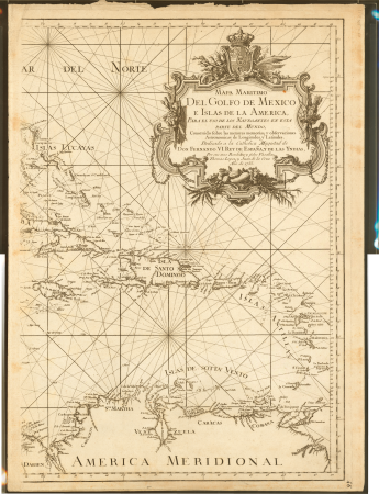
![Gerardi Mercatoris and I. Hondii Atlas or Representation of the Universal World, and of the Parts of It, Made in Tables and Very Ample Descriptions. [t. 2].](https://cdn.creazilla.com/illustrations/10001261552/gerardi-mercatoris-and-i-hondii-atlas-or-representation-of-the-universal-world-and-of-the-parts-of-it-made-in-tables-and-very-ample-descriptions-t-2-sm.webp)
![Gerardi Mercatoris and I. Hondii Atlas or Representation of the Universal World, and of the Parts of It, Made in Tables and Very Ample Descriptions. [t. 2].](https://cdn.creazilla.com/illustrations/10000735247/gerardi-mercatoris-and-i-hondii-atlas-or-representation-of-the-universal-world-and-of-the-parts-of-it-made-in-tables-and-very-ample-descriptions-t-2-sm.webp)


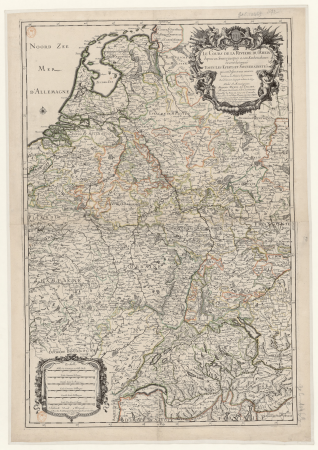


![Gerardi Mercatoris and I. Hondii Atlas or Representation of the Universal World, and of the Parts of It, Made in Tables and Descriptions Very Ample, and Exact: Divided into Two Volumes [...]. [t. 1].](https://cdn.creazilla.com/illustrations/10000205839/gerardi-mercatoris-and-i-hondii-atlas-or-representation-of-the-universal-world-and-of-the-parts-of-it-made-in-tables-and-descriptions-very-ample-and-exact-divided-into-two-volumes-t-1-sm.webp)

